Gleaves Family
- Welcome
- Family History
- Letters & Diaries
- Folder: Information
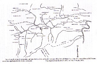
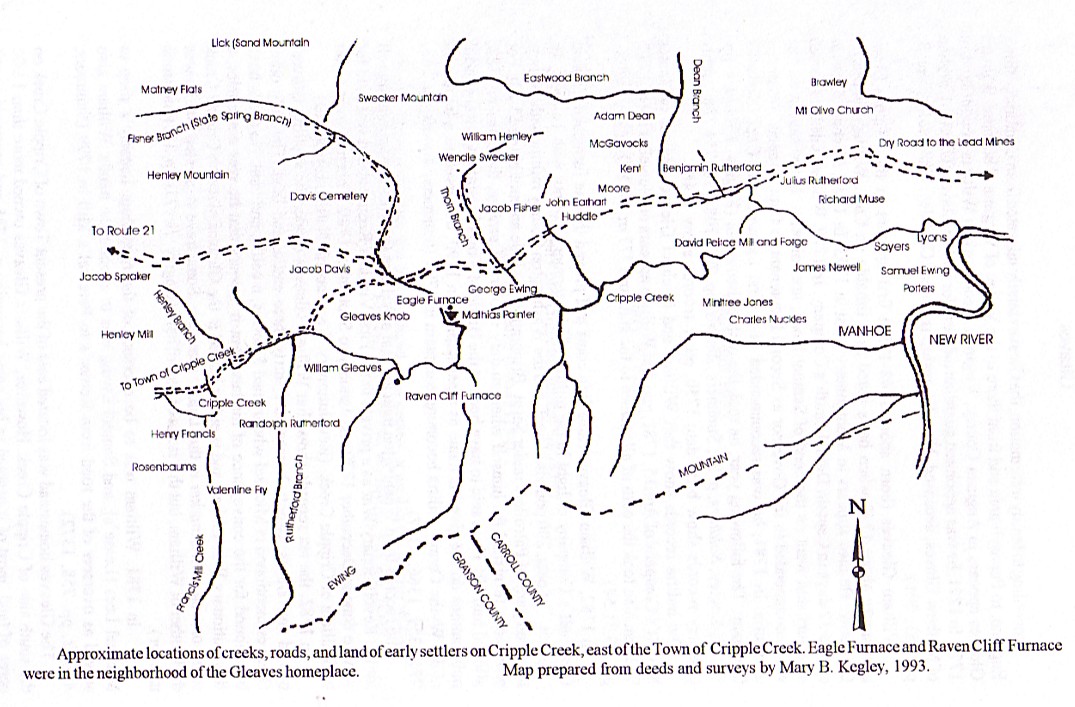
- 20 - Cripple Creek area of Wythe County showing land owners
 20 - Cripple Creek area of Wythe County showing land owners
- » Date: n/a
- » Subject: 20 - Cripple Creek area of Wythe County showing land owners
- » Written By: unknown
- » Addressed To: unknown
- » File # Info - 20
 Page 1 Image
Click to see the full imagePage 1
 Page 1 Image
Click to see the full image
Map showing the approximate locations of creeks, roads, and land of early settlers on Cripple Creek.
From EARLY ADVENTURERS ON THE WESTERN WATERS, Volume III, Part 2, page 446 by Mary B. Kegley
Used with permission from the author, Mary B. Kegley
REMEMBER to click on the image to the left for a larger image. Then click on the larger image for an even larger image that is easy to read.
 Folders
- Information
- 1700s
- 1800 - 1819
- 1820 - 1839
- 1840 - 1859
- 1860 - 1879
- 1880 - 1899
- 1900 - 1919
- 1920 - 1939
- 1940 - 1999
- Drawings
- 2000s
- Practical Arithmatic
- Memo Book: JTG 1819
- Ledger: JTG 1827-1834
- Ledger: JTG 1836-1841
- Ledger: JTG 1841-1849
- Ledger: JTG 1849-1854
- Ledger: JTG 1852-1855
- Ledger: JTG 1854
- Ledger: JTG 1859-1868
- Catalogue: Emory & Henry
- Ledger: GWG, Tax Collection, 1850
- Ledger: JTG Jr 1850
- Diary: Betty Gleaves
- Acct Bk: Wythe Minute Men
- Ledger: East Tennessee
- Ledger: Company Description 1863
- Ledger: RHG 1870s
- Ledger: RHG 1876-1882
- Ledger: RHG 1882-1901
- Inventory: E. K. Byrd
- Ledger: Misc 1870s
- Writings: Laura Keene Gleaves
- Cookbook: 1893 Ladies Aid Society
- Order Bk: JTaylorG
- Ledger: JTaylorG 1909-1919
- Ledger: JTaylorG 1909-1945
- Writings: Anna Gleaves Rich
- References